Low cloud and smirr isn’t a good start to the day but plans had been laid the previous evening to head into what is literally the middle of nowhere in the south part of the Muirsheil park area. Roddy 2MØIOB and myself had spoken of ‘exploring’ the area to the west and south of Hardridge Hill which lies 6 Km W of the town of Kilmacolm.
Roddy arrived and off we headed through country roads until we came across our first stop, the dark ruins of Duchal Castle.

Duchal Castle east wall
The castle was built at the junction of the Green Water and Blacketty Water, the ruins are at NS 334685. I have never visited the ruins and was pleasantly surprised to find there are still part of the ramparts standing, this castle was built with walls which must be approx 3ft thick in parts. The area is slowly being overgrown by trees but is well worth a visit during the day as there is mention of a ghostly monk and he is reputed to be an evil spirit who roams the castle area. Interesting part is that the ‘monk’ originally haunted Paisley Abbey and then made his way to haunt the ‘House of Duchal’.
The castle itself was built in the 13th century by Ralph l’Isle ( later Lyle) who had Norman connections.
The most famous incident at the castle took place in mid 1489 when King James the 1st laid siege to the castle and is reputed to have hauled the famous ‘Mons Meg‘ cannon to lay siege to the castle and reputedly on sight of this formidable piece of weaponry, the castle inhabitants surrendered. A second large cannon was ‘fired’ and was later renamed ‘Duchal’. A quick look on the NE side wall shows a ‘garderobe’, this feature was possibly either a medieval toilet or rubbish chute.
An atmospheric place to visit on a grey, misty day and of course a wandering spirit to meet although he is thought to have disappeared after a fatal tussle with one of the Lyle family.

Grouse Railway shed
Leaving the castle ruins, we headed to park up not too far from the tarmac single track road (we parked at the side of the road at NS 330682) which would lead us up to join the moorland track to lead us to the Grouse Railway and the track then heads westwards and leads out towards the base of Knockdal Ring and Laird’s Seat. This moorland has the Grouse Railway crossing it in many places.
Heading up the ‘Hardridge’ single track road, we passed through a gate which opens up on to open countryside occupied initially by ‘heilan coos’, the track rises steadily upwards and over to our left is the original engine shed of the Grouse Railway.

The Roddy fella
Roddy led us through deep mud as the local cattle have their feeding bay in the lee of the Engine Shed, the first track leads away towards Hardridge Hill and I stood on the remains of what seemed to be a platform. Tracks also headed west and as the OS map shows the moor is criss-crossed by tracks as we were to find out further out.
It was time to head out the track which was to lead us to a dead-end/turning point three miles further out, the track is in good condition with the occasional wet muddy area but is easily passable. This track shows on the 2010 OS map but not on any earlier edition.
Each sighting of the railway looked at and at NS 302675, a side track heads southwards towards the Muirsheil Mine track which in turn takes you to the Ranger Centre. The track we were to use was built to accommodate the transport of materials for the building of the railway although if baryte mining did take place in earlier times at Lairds Seat, a track may have previously existed.

Track over Blacketty Water
Just next to the junction of tracks is a good example of a bridge crossing the burn and later on our return we looked at the north side of the track which has railway points etc. Occasionally on the moor a single stake would show the remains of a grouse butt. One mile on, the track ends in what is a turning area from which we headed towards a high spot to the west across knee-deep heather and a very wet mossy underfoot.
A quick look around from this hillock and a decision to head back to the turning area to enjoy some scran if the weather came in, this area is featureless and care must be taking if going off track. Just before we arrived at the end of the track, we heard and worked Bob AWV who was activating Cairn Table to the south of us in Ayrshire. Roddy later called out on fellow club member Brian who was in Howwood. Time to head back the three plus miles back to Roddy’s Land Rover literally it was all downhill from here.
We had a further look at the rail tracks we spotted and a couple of points systems still intact. It was not long before we headed across the wet and mossy rise to Hardridge Hill and its trig point, a look at the local landmarks which were visible but due to the grey misty and cloudy day, the further views were hidden so a return on a sunny day will have to be made. I did call out on both 4m and 2m FM but the usual response on a Sat afternoon, nothing. Heading back to the track and having a last look at the engine shed, we closed the last gate and headed down the tarmac road to the Discovery.
Further on to my mention of royalty visiting(or sorting out the locals) at Duchal Castle, I must add that King Edward VIII also graced the railway and no doubt more than a brace or two was flown in his royal direction. Thanks to my sidekick, Roddy for reminding me of this occasion.
A trip worth repeating on a better weather day.
Thanks to Roddy for transport and having to listen to me for an afternoon.

Yer man at Hardridge trig point
Further References..
to Duchal Castle HERE
to the Duchal Grouse Railway HERE (other links to same in article)
The bridge shown and the triangulation junction( N side of track) is at NS 301675
‘Duchal’ is translated in a few ways, first is ‘the black stream’ (reference to the Blacketty water) and from the gaelic word ‘dubh’ meaning black and as ‘between two rivers’. they all seem to fit.
Thanks go to Roddy for use of his images in this blog piece also again to Wikipedia and other information sources.
Please feel free to click on any image, the main blog post images will open to full size and the small thumbnails at the foot of the post will open up a ‘Gallery’. If you right click on the thumbnails, some browsers will allow you to ‘open in a new tab’, this will give you the full sized image.
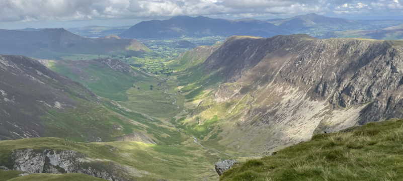
The panorama from Hardridge Trig Point was taken when the day had brightened up and yes, it was windy.


A superb piece! Was that today? (Sunday) I was mooching around the B788 today, not much action
Off road except the track parallel to Port Glasgow Golf Club.
Take care
H
An excellent day oot, cheers for the flattering photos ;-). Excellent info on the castle, I didn’t know any of it. We’ll book some sunshine for the next one.
Roddy IOB.
Hugh,
Nope it was Saturday although today’s weather was the same.
I did notice fresh tyre tracks on the Green Rd (Devol Rd) as I passed over it this early afternoon.
The trip to the castle was an ‘extra’ on way to the trip into the middle of nowhere but you know the tracks referred to.
Ta for the comment (no marking up my use of the English language, please!)
Bobby
Roddy,
Sunshine ? let me think…
Yon big yellow ball in the sky?
Aye a grand day not spoiled by the weather at all.
The next time..
Bobby