(May) Radio Days…..2011

Another month on..

SOTA activity..

One activation to report.

On the first day of the month, Cruach Ardrain was the choice on the second day of the now annual International SOTA weekend. An excellent day weather wise apart from 60 mph winds reported around the summits. Ardrain strangely wasn’t as tough wind wise. A total of 8 STS (summit to summit) contacts made as far North as Beinn Eighe – Ruadh Mhor and south to Kirkland Hill in the Galloway Hills.

I also achieved my 100th activating point on Cruach Ardrain, 27 summits now done in total. It was the toughest hill I’ve walked yet.

Cruach Ardrain summit from the ridge walk

Cruach Ardrain summit from the ridge walk

Chasing…

A good start to the month as I finally achieved Shack Sloth status.

First into the log was a contact with Robin PKT on Gaor Bhein (Gulvain), this contact made on the ascent, the first contact on the summit was an STS with Bob AWV and Eunice UVL on 70cm, both were on Duncolm Hill. Followed by blog regular Neil 2MØNCM on Kirkland Hill followed next by a line of sight contact with Barry XFM who was nearby on Ben Lawers, another blog regular Graeme 2MØGIL had set up station on Conic Hill. Jack COX had taken up station on his local hill Dungavel whilst the last points came from Colwyn YCJ on the aforementioned Beinn Eighe – Ruadh Mhor approx 150km to the north of us. A good finish to a good day. Shack Sloth was in the bag !!!!

The following weekend, I worked Alan TXY on Ben Venue ( I hope he saw more than I did when I activated the said hill) and the same man was out the following weekend on Beinn Dubh, west of Luss. The next day I nipped up the golf course to work Neil 2MØNCM who was activating Black Mount, Neil was ‘activating’ other hills that day but unheard from my home QTH.

Finally on the last weekend of the month, Bob AWV popped up on Meikle Bin on what was a very windy day.

The weather had not been kind for May activations with high winds and rain dominating the month’s weather after such a fine start weather wise.

Activity…

Occasional monitoring of 2m FM, 4m FM locally has a lack of activity and I’ve taken down the 4m antenna I had in the attic and will replace it with a 6m one but not decided which one yet. HF conditions have been in and out but still managed a few data contacts on PSK. New DXCC country in Faroe Islands.

I had sent a few CQ calls on 17m to an apparently dead band and was surprised to see a JA station returning to me, contact made and the band returned to being dead, strange thing propagation. It is always worthwhile to call on an ‘dead’ band.

WSPR…

Had a few sessions on 30 and 20m bands and as usual, the mode returned some good results. Five watts can certainly travel far. Further info at WSPR.ORG

20m WSPR 13.20 - 14.20 UTC on 22.5.11

20m WSPR 13.20 - 14.20 UTC on 22.5.11

ROS…

Yep, I had a few days off work and decided to give another data mode a try. I chose ROS which is having a rather chequered introduction to the radio world, I downloaded the software and was working almost immediately. I’ve now made contacts into Europe although I must get organised at looking at the settings as I’m seemingly a bit deaf on receive…but the general interface is easy to navigate and I’ll be active occasionally…

ROS Info <HERE>
(April) Radio Days….2011

VHF….

Working 2m from home, still monitoring 4m FM and 70cm but not much activity.

SOTA….

One activation this month, a visit to King’s Seat in the Sidlaw Hills to the W of Dundee.

Chasing..

First in log was two summit to summit contacts from the top of King’s Seat, Iain WJZ was first, Ian was on the summit of Corserine in the Galloway Hills, a cracking STS across country and Barry TOE was to the N on the summit of Mealna Letter for the next STS, a worthwhile activation for me.

Looking NW to the Lawers Range

Looking NW to the Lawers Range

The following weekend, I worked Jack COX on Dungavel Hill and later that day, Iain WJZ on Sgor Gaibhre. On the Sunday, Bob AWV was on Conic Hill near Balmaha and this day it was the turn of Neil 2MØNCM to be on Dungavel Hill. The following Sunday, I made tracks to Corlic as a few alerts were posted. Firstly fellow blogger Graeme 2MØGIL was on Beinn Dubhchraig whilst at the same time, Neil 2MØNCM was making up his way up to its sister summit of Ben Oss

Looking to the Lui summits

Looking to the Lui summits

whilst unknown to all of us, Alan XXP was making tracks up Ben Lui a stone throw to the N of both hills. Next in the log was Alan EYO who was on a GM land activation holiday, Alan was on Schiehallion to the NE. In a busy day chasing wise, Jack COX was to the south of EYO on Meall Corranaich in the Lawers range. 40 odd points in one day, nice one.

I noticed another visitor to GM land was activating Ben More on the Isle of Mull mid-week so I monitored S20 waiting on him, the points from Gerald AQU were in the bag. A couple of days later, Corlic was my base while Robin PKT started his day off on one of the Beinn a’Ghlo summits followed later by a visit to the summit of Braigh Coire Chruinn-bhalgain, I heard his third activation as I headed back home but failed to make the contact.. In between this, Neil 2MØNCM was line of sight on the Hill of Stake, hill for some reason that some activators hate, dunno why ?.The Holiday Monday I was on Corlic again to chase Graeme 2MØGIL as he was to activate two ‘Munros’, Sqiath Chuil and Meall Glas but whilst I waited on Graeme, Seamus OVV activated Conic Hill, another point.

The next weekend was another holiday weekend and on the Friday, Robin PKT activated two of the hills which make up the Great Wall of Rannoch, first I worked him on Beinn a’Dothaidh and next on Beinn Dorain, the next day he was back out and I ‘chased’ him on both summits of Buachaille Etive Beag whilst at the same time, Gerald AQU popped in to the frequency and Stob Ghabhar was in the bag.

A frenetic month and my quest for Shack Sloth status was about to be realised with just a few more points to go.

HF…

Still scanning the bands from 40m to 12m looking for psk contacts. Working European stations with the odd sprinkling of stations outside. One new DXCC in SV5 Dodecanese Islands in the Aegean Sea. I occasionally had the WSPR set up in operation but for no extended period, 5 watts can certainly carry far in this excellent mode. I’m using what it I guess a ‘stealth’ antenna partially inside my loft space and finally running down behind the outside downpipes. It isn’t the best but it gets out there, five continents so far…

Another thanks to Wikipedia for outside links..

If Donich is a 10 then Cruach Ardrain is a 7

Aye right !!

Activation of Cruach Ardrain GM/SS 004 1/5/2011

Activation of Cruach Ardrain GM/SS 004 1/5/2011

ISW or International SOTA Weekend was looming and the hunt was on for a summit, a few possibles were looked at and finally, Cruach Ardrain was the choice with a backup of a lower hill just in case of weather problems. The usual palaver of pouring over maps, checking for routes in the Scottish walking forums but as a couple of fellow bloggers had already ‘climbed’ this hill so email was duly fired out for advice, Graeme had made his way from the South from the Braes of Balquidder whilst ‘baggingBeinn Tulaichean on the way in. Neil (of whom the title of the post refers to) had accessed the hill from the A82, this was the route chosen as it seemed the easier of the two.

Once again the activating team of 2MØIOB (or 2RØIOB this time) and myself headed swiftly northwards to find the parking spot at NN368238 which was busy even at the early time of 8am. A quick look and the summit was viewable from our setting out point. A check of equipment and it was off over the stile heading to the railway bridge underpass which leads onto a rough track which had been driven into the glen possibly for grouse shooting.

Our track now veered off to the left and said goodbye to a couple of walkers we had met and who were heading on to An Caisteal. We now reached the rickety bridge which was gingerly crossed and then it was now into the serious stuff, a relentless upward slog over grass following a faint path along a forestry fence, the first scran break was taken just before the end of this section.

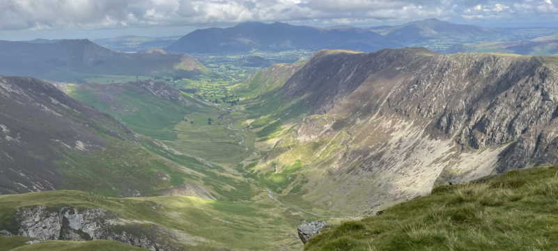
It was then upwards until we met the start of the ridge walk which would take us to the last uphill push to the summit. A quick rise to the top of Grey Height then a gradually rising ridge walk where the all-round views were improving the more height we gained, Crainlarich with its green valley and looking N you could see the recognisable shape of Beinn Dorain and to the west the summits of Bens Lui, Oss and Dubhchraig. The twin peaks of Ben More and Stobinnean were constantly in view to the E until we met the summit of the ridge walk which has Meall Dhamh to your left. We could see the summit cairn and thought ‘eh ? have we got to go there? we had to.

The summit from the top of the ridge walk

The summit from the top of the ridge walk

It was now descent time into the bealach 150 ft below then it was a quick up and over another lump of rock until it was time to strike up the last steep section, this was proving a bit of a hill too far for myself. Just as we struck out for the top, we worked Robin PKT who was on Gaor Bheinn (Gulvain) then relentlessly we drove on and the summit was slowly getting nearer but every time I checked the gps phone app, I swear the summit was moving further east or I was going in reverse. Roddy then pressed on but just at the point I was cussing under my breath at my stupidity, I met the path between summits and off I headed (slowly) to the left and after another up and over, the summit was metres away.

I first, headed to the summit cairn and touched it. Sadly there was no trig point (white or otherwise). Roddy by this time had ‘activated’ the hill. I had a quick scran break and although windy I put up the 4m JPole and proceeded to call out, 15 mins later and with no contacts it was down with the 4m antenna and the 70cm JPole erected in its place, nothing again until I made contact STS (summit to summit) with both Bob AWV and Eunice UVL who were on Duncolm in the Old Kilpatrick Hills, I tried again but no takers. A bit disappointing as I had thought 4m would have been good from over 3,000ft but it was a cracking sunny day and I guess most sensible folk would be out doing more relaxing things than playing radio.

I headed back on 2m and worked Dave TAP who was in the Selkirk area then STS with Neil who was on Kirkland Hill near Kirkconnel, next STS in the log was Barry XFM who was just to the E of us on the summit of Ben Lawers. Next was by fellow blogger Graeme 2MØGIL who was on Conic Hill near Balamha. Jack COX was out hunting STS, Jack was on Dungavel Hill in Lanarkshire, next in the log was Christine YMM from Edinburgh and finally, a cracking STS to finish the day was with Colwyn CYJ who was in the Wester Ross region NW of us on Beinn Eighe – Rhuad Stac Mor near Kinlochewe approx 150 km away.

It was then time to break down the station and head back of the hill, slowly but surely the steepish section was manoeuvred and it was time to climb up the 150ft to the ridge, this was painful but soon done and it a pleasant walk back down to descend off the Grey Height and now the relentless plod down the steep grassy slope until we took a break at the ricketty bridge before the last walk down the track to the parking area on the A82. The walk was finally done ( and so was I !)

A last look at Cruach Ardrain summit then it was off back to civilisation.

Would I do it again ? No…

Would I recommend it.. Yes !

A contrast in answers but the views from the summit cairn were fantastic, too many summits to name but the twin peaks of Ben More and Stobinnean were as if you could reach out and touch them, Ben Lawers showing through their bealach, the Tarmachan ridge, Ben Nevis with its patches of snow, the trio of Lui, Oss and Dubhchraig, Ben Lomond, the Trossach hills Venue and Ledi and an old favourite far on the south horizon, the Hill of Stake.

Rather interestingly, ‘Naismith’s Rule‘ was created during a walk on Cruach Ardrain on the way to Ben More, obviously my pace wasn’t taken into consideration.

My thanks once again go to Roddy as he suffered my slow pace etc. Funnily I’ve just received a text from him about a much lighter pack will be carried next time, I must be staying at home….

I’ll explain the title of the post..

I asked Neil his views on how ‘hard’ the ascent would be and that was his reply….I fell for it again.

Information Overload…

Cruach Ardrain means ‘Stack of the high part’ or some say ‘Heap of stones’…

it is 1,046m ( 3,462 ft ) ASL

is 87 in the Munro list

Geohack info <HERE>

Round trip of over 12km.

All photos of activation <HERE>

(

A Windy Day for a Long Winding Walk……

Plans had been laid midweek but the forecast 24 hours before Saturday morning was not looking promising so if dry, an alternative walk had to be found so a local jaunt was planned.

The Greenock Cut, the walk starts at NS266748. (car parking is available)

It has been several years since I last walked the Cut aqueduct above Greenock, a long winding walk alongside an engineering miracle of the 19th century built by Robert Thom and for many a generation of any Inverclyde resident this is their first walk into the local hills. The relatively flat walk spreads over 5.5 miles(9km) with rough rising  moorland to the south and steep grassy slopes which follow the hill contours and run parallel with south west Greenock, sadly the day had poor light and low cloud which denied me the picturesque views to the North and West which must be seen.

I had left home and was travelling to the Waterman’s House at Overton when Roddy 2M0IOB contacted me to say Conic Hill was being activated. I arrived at my destination and had a quick check of my handheld but Conic Hill was missed. I started along westwards with the aqueduct on my left, most of the little bridges have been repaired and the stone bothies which the watermen had used have mostly fallen into disrepair.

To my right, Greenock lay sprawled out as far as the eye could see. First of all, to the south , the microwave masts of Scroggy Bank came into view.

Roddy, good lad that he is, now contacted me to say Bob, a local MM1 station was activating Ben Bowie so I took out the 2m handheld and made the contact with him. Another chaser point in the bag.

As you walk further along you now start to leave Greenock behind with countryside and the IBM factory in Spango Valley coming into view.  The path starts to wind gently towards Cornalees, immediately on your right is the farm of Dunrod, near the ruins of Dunrod Castle where Auld Dunrod, a local of legend once lived.

Read on :

The nearby parish of Inverkip’s biggest claim to fame was to witchcraft in the mid 17th century.

A verse recalls
“In Auld Kirk the witches ride thick
And in Dunrod they dwell;
But the greatest loon amang them a’
Is Auld Dunrod himsel’.”

‘Auld Dunrod’ was the last of the Lindsay family of Dunrod Castle. As the result of a dissolute life he lost all his possessions and fell into the black arts. Local reputation had it that he was in league with the devil, and he died in mysterious circumstances in a barn belonging to one of his former tenant farmers. Nothing now remains of the castle which stood at the foot of Dunrod Hill. ( My thanks to Wikipedia for this)

The path now starts to turn south eastwards taking in the start of the Shielhill Glen with Inverkip and the Kip Marina in the distance. The steep slopes of Cauldron and Dunrod are on your left and soon you reach the road which splits the track in which once you cross the road the track heads southward along the top of  Shielhill Glen, this area has been set out with seats and picnic areas when you reach a waterfall which is the overflow from the Compensation Reservoir, the Cut path now ends and you can now cross the road to the Greenock Cut Visitor Centre, this centre was formerly known as Cornalees Visitor Centre, this is part of the Clyde Muirshiel park.

You now have the option to either look at the exhibition in the Centre or use the Cafe or have a picnic outside. Loos are available.

Heading on the road eastwards, you come to start of the Kelly Cut at NS247720 which leads you to Wemyss Bay 6 miles (9km) away. The path at its start has many seating areas until you leave the trails area behind, the path becomes slightly soggier in places, you now look back and can see Dunrod Hill and looking eastwards Corlic Hill.

The Daff Reservoir, a fantastic shaped water appears on your right and after the Daff , the scenery is not inspiring with rough cut forest to your right and rough moorland to the left, I did notice that someone has been chiselling away at a  thin seam of quartz at the Cut side, gold maybe ?

You next leave the single track on to a rough vehicle track and after a short distance, the Kelly Reservoir hides from you to the south where you now track westwards and meet the first piece of uphill track , once you reach the top , you see (or you could have on a better day) Bute and the Mull of Kintyre. A long downhill tramp comes next and then you reach a tarmac single track road and once passed the farm , a track suddenly veers downhill to your right, this is the original Kelly Burn track but having been advised to its being rather muddy in places. I took the road down to the main caravan park and followed the road down to Wemyss Bay and the railway station.

I travelled back to Port Glasgow on of Scotrail’s finest carriages from whence was a lift home and back to civilisation.

The walk ? I would thoroughly recommend the Greenock Cut walk, the Kelly Cut walk ? why not, it adds interest and gets you off the beaten track, I walked from the Visitor Centre and never met anyone until I reached the Caravan Park, total solitude.

I would recommend a clear day as the views could and would have been better.

Please note a new sub section on the above menu , I have added a Local Interest ‘tab’, self-explanatory really. Walks plus visits to local interest ‘spots’ amongst other stuff.

please excuse photos in Flickr set, light quality was poor plus I used my mobile phones inbuilt camera.

Photo set <HERE>

Only for the distance travelled

Google Map details <HERE>