
The now annual short trip to the Lake District was nearing and my thoughts turned to ‘Where this time?’.
Pouring over maps and routes which seems to be an enjoyable part of all this activating lark, I settled on Blencathra.
This hill had been activated many times but as one of the most popular hills in the Lake District I expected to see this plus I noted that earlier this year in March regular blog reader Iain WJZ had been one of those.

SOTA Activation of Blencathra G/LD 008 on 8/08/2012
I had passed many times beneath the south face of Blencathra or Saddleback as local friends use when talking about this impressive sight as you head along the A66 towards Keswick. It was my hill of choice on this short three-day visit.
I had prepared maps for this and other alternative summits but as we left home to head the just over two-hour journey south, the sky had nary a cloud to be seen. After days and days of almost daily rain this sight was most welcome and as we headed south along the M74, the sky was now showing more cloud the nearer we came to the border.
We stopped outside Carlisle for our brekkie and soon fully fed and watered. ASDA do one heck of a breakfast.
I had seen the Northern Fells as we headed towards Carlisle and soon we left the motorway heading west on the A66 to Threlkeld where after a short drive through the village I would get dropped off at OS ref NY 302256.
Katie said goodbye and straight from the off it was straight up steep, I had chosen to take the route up Blease Fell from the ‘car parking’ area behind the Blencathra Centre.

Derwent Water from the ascent
Slowly and relentlessly I headed upwards pausing to take in the cracking views looking back towards Keswick, Derwent Water and the nearby fells. I met a few walkers who had made it a round trip accessing the hill from the more common ascent of Scales Fell. Keeping heading up what was a dry well-worn path I stopped after an hour to have my customary scran break, I was watching a walker doing the direct route and soon he passed as I had a final swig of water and headed towards where the path zig-zags before finally starting to ease towards Knowe Crags and soon I saw my intended target Hallsfell Top the summit of Blencathra. Looking back towards Skiddaw, I could see nestled in the hillside Skiddaw House which is the highest hostel in Britain, more information HERE. Isolation at its finest.
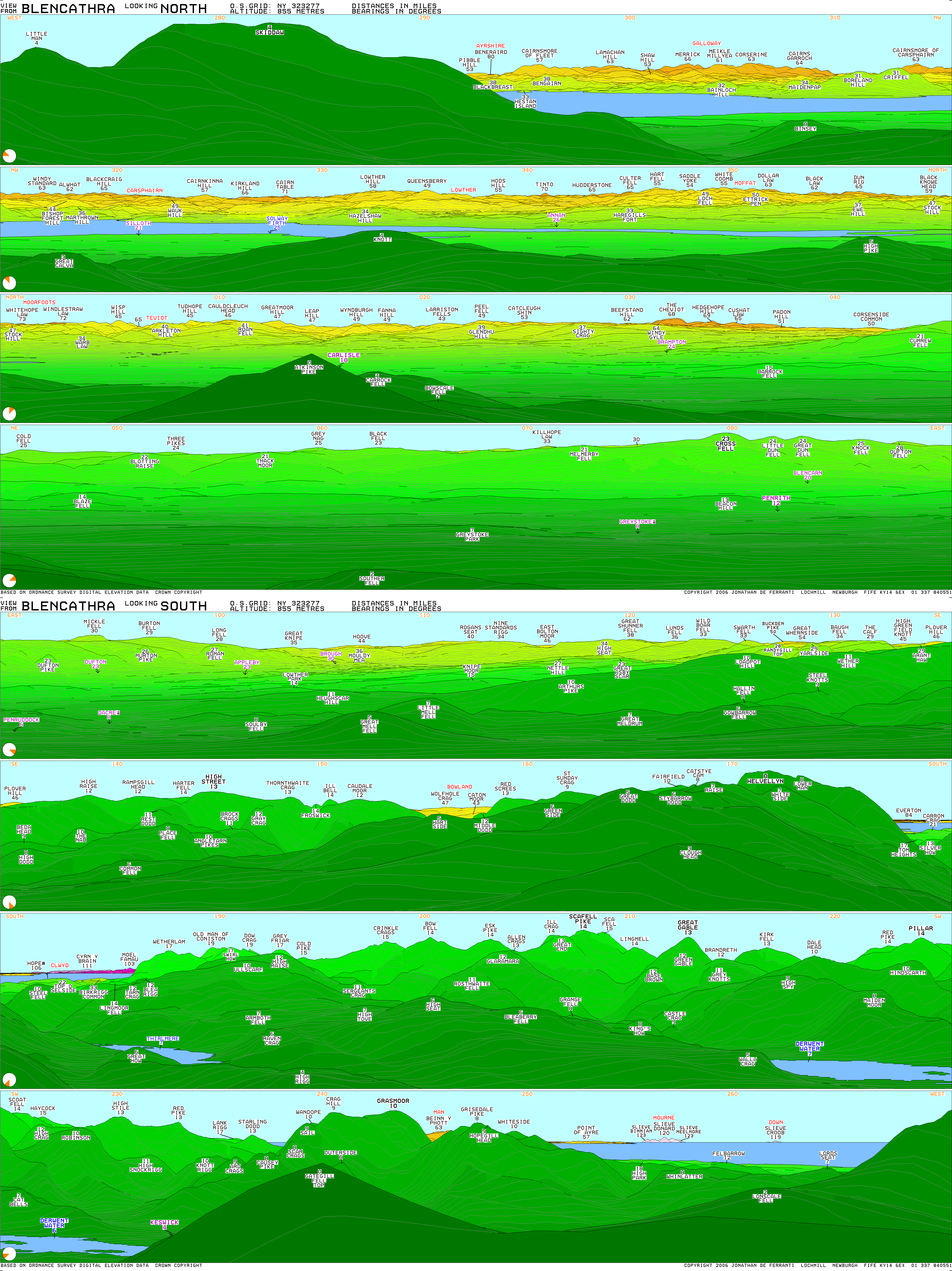
Once I reached Knowe Crags, the ascent was more gentle rising towards another high point above Gategill Fell before the last easy ascent along the ridge towards Hallsfell Top, the views in 360 degrees were stunning, I looked NW to the Cairnsmore of Fleet, the Merrick among other Galloway Hills and to the SE, S , SW and W the fells of the Lakes with the odd cloud covering the higher tops and just to the west Skiddaw‘s summit was clearing.
I took in the views whilst dropping just slightly below the summit to set up the mast and beam. I had been in touch with fellow blogger Neil 2MØNCM on my way south and had asked Neil to post an alert on the SOTA site for me, time of arrival had been almost left open but I was more than glad of my ascent time being a bit under 2 hours and only one person passing me on the ascent, we had a quick chat and he said that the guide books point you in either Scales Fell or for the more adventurous Sharp Edge and how they recommend you stop occasionally to look back and take in the fantastic views but this way you get the ‘alleged’ better views on the descent.

The ridge walk to Hallsfell Top
I set up the 2m beam to quips of ‘ What time are the Olympics on?’ and ‘ You don’t need a satellite up here’, yep the hill was full of wags today, the comments kept coming all the time I was there.
I had first looked for Neil as he and Cat CNC had headed out to ‘chase’ me from Pinbain Hill in South Ayrshire but no joy initially but you will find out later why.
Off it was to 145.500 and first to reply to my call was Geoff WHA in Penrith with whom I had spoken on my Lakeland visit last year. Next in the log was John TDM also from nearby Penrith. To the west Malcolm XAT from Seaton called me and next was Colin XSD in the same area. I spoke with Ed PYE who was passing beneath me on the A66, Ed was also in the area for a short break.
Coiln UXH called in from west of me and he had told me that Terry VSP was on Claife Heights a WOTA/ SOTA summit to the south of me near Windermere, the first of two summit to summit calls. Further SW was Brian ZRP who called me from the Wirral area approx 140 kms away.
I had swung the beam around in a 360 direction stopping occasionally to call out as I knew Irish or Scottish contacts could be made from here but the band had gone quiet or so I thought.
I heard my phone ringing and it was Neil asking me to beam NW as I was loud and clear to them so off I beamed that way again, nothing….Something isn’t working here. I had just worked a station in the Wirral area with no problem and had never thought I had any problems but I removed and replaced the handie with my 2 watt Baofeng, I called and voilà !! Neil and Cat with no problem at all. Following Neil and Cat was another summit to summit to North Wales to Phil CJJ/p who was on Mynydd Bodafon on the Isle of Anglesey, this being made with Phil using the bog standard duck antenna that came with his handheld radio, excellent contact. Lastly another contact to the Isle of Anglesey with John GUX. Both of these contacts were roughly 170 km away under normal conditions. A good sea path obviously helps.
The other handie had been deaf on receive and I am wondering if it had been that way all along on the earlier part of the activation. A call to Neil later that evening had confirmed my suspicions that it had been deaf from the very outset, I will have a look at it but if nothing obvious I may just replace it. I wonder if I had missed any other contacts.

Sharp Edge
After the last contact, I started to strip down the beam and mast and noticed that I was the only person on the ridge and summit area it was an eerie silence after the constant stream of folk summitting. I sat at the summit taking a last 360 look whilst taking on more water and food for the descent. A lone fell runner came towards the summit from Anderson Pike and I decided to head that way to have a look at the ‘white cross’ which has been laid out on the grass, the origins of the ‘cross’ is split between two camps, a memorial to either a fell walker who died nearby or a late gamekeeper from nearby Skiddaw House, Wainwright himself had gone with the fact that a local Threlkeld resident had ‘built’ the cross to its present day size. I was not too far from where Sharp Edge meets the plateau but I headed back down the main path off the summit whilst marvelling at how impressive Sharp Edge looks from the main path, I could see a couple of brightly coloured figures slowly ascending.

Looking to Scales Fell and beyond
Down a well-worn path and passing a large family group who had decided to turn back just short of reaching the summit plateau, 10 mins would have had them at the top. Strange decision. I slowly descended taking in the views and yet another fell runner ran breathlessly upwards past me and before long off she passed descending quickly into the distance. There is a maze of paths at this side of the hill so I followed the main one down and decided to head and take the path which steeply descends Mousethwaite Comb and comes out to a track which leads back to the village of Scales where I had arranged my pick up point, I crossed the busy A66 and threw my equipment into the car and off we headed back to Cockermouth.
An excellent day spent on a more than worthy hill, I will look at this hill each time I pass ans who knows I may do the reverse route some day. It was good to find good dry paths with no boggy patches to find your way around.
My thanks to Katie, Wikipedia and Peakbagger and those I have linked to.
I did a quick activation of Latrigg Fell the following day ( short blog post to follow in a few days)
Information overload….
Blencathra means ‘ the bare hill shaped like a chair’ from the old Cumbric….
or Saddleback is self-explanatory.
Height is 868m (2,848 ft) asl..
Computer generated panorama HERE
Peakbagger info HERE
For further reading on Fell Running, just google Billy Bland or Joss Naylor and just to put all this into perspective, Billy Bland holds the record for the Bob Graham Round, a race which takes in 42 Lake District peaks over 66 miles long, his record ? 13 hours 53 mins. Joss Naylor expanded the round to 72 peaks involving over 100 miles and 37,000 feet of ascent in 23h 20m. Incredible achievements.


