I had worked one of our regulars, Neil, 2M0NCM on Donich last year. I had intended to activate it at the end of last year but if you are a regular reader of the blog, you know I never got there.
I had the chance of ‘activating’ on the Saturday and kept a watchful eye on the Met Office site, the weather forecast was looking good, misty in the morning but clearing in the afternoon, they got it correct.

The Scramble
My daughter Lora kindly drove me to the top of the Rest and Be Thankful and to the forestry car park where the Donich walk begins. I looked skywards and saw little, cloud and mist were skirting over the first part of the climb. I set off and slowly started to make height on a well made path which suddenly disappeared, quite possibly the top bit of the path has washed away. I passed through the gate which then let me on to the real stuff, the path is a classic hill path, showing in most places and occasionally disappearing, slowly I made progress, Neil had told me it was a moderate climb, for me? steepish in most parts.
I stopped and had a ‘food’ break after one hour of climbing, the mist was still skirting quickly over the hill. The top was not for showing this early. Ten minutes later, off I started uphill until I came across the ‘the scramble’, it is a drop down of approx 20 ft ? but with good hand holds it was no problem, I then rather foolishly took a short cut down a flattish rock, I slipped and cut a finger, it looked nasty at first but once cleaned, I carried on.
The summit you see as you climb upwards here is a false one, near the top of this, I met a lone walker on his way down and after a quick conversation in which he had said ’10 mins to the top’ then at the top of this false summit, the path veers eventually leftward and through the mist I could see the trig point.

The Cobbler with Beinn Narnain
The going was relatively flattish by this time. Two notes of warning, there are many cracks and fissures around the path edges and if you misjudged one of these, it could be dangerous. Keep to the path but secondly, the path disappears in places on the last trudge to the summit so if coming off in mist, keep on the path once you find it. Steep drops abound on this walk.

Ben Lomond
I reached the trig point.
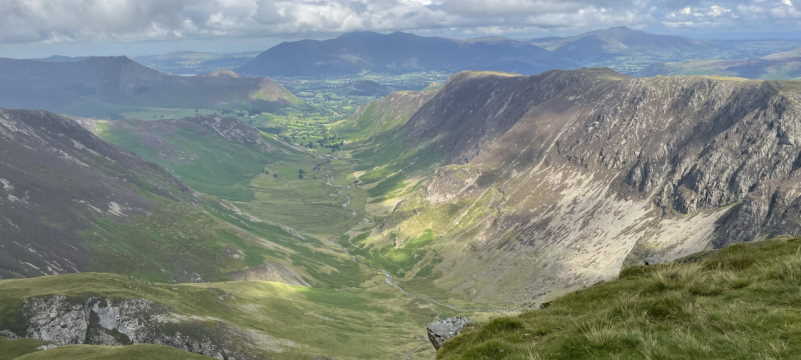
As I reached the top, the cloud and mist started to disappear slowly, the view was stunning, the list of nearby hills include Beinn’s Ime, Luibhean, an Lochain and Narnain. The Cobbler ( Ben Arthur) is just to the north, The Brack and Cnoc Connich, Ben’s Lomond, More, Oss and countless more are viewable. I could see my home area. The view down the Firth of Clyde is stunning.
The mast was quickly erected and 2m FM tried first, I first worked seven stations, had a quick break and set up for 4m FM, I made four contacts including one to the Isle of Whithorn area in SW Scotland. I had another food break then on going back to 2m FM, I called and spoke to blog regular Graeme, 2M0GIL who was portable in the Whangie area then had another six contacts including a G1 station on Skiddaw in the Lake District then it was time to break down the station and head back down the hill.

Looking down the Firth of Clyde (Loch Goil in foreground)
I followed the path back and on reaching the ‘the scramble’, I sensibly kept to the path this time, climbed to the top and headed slowly down to the parking area. It was good to have done this hill, I was most surprised to complete the uphill section in just 2 hrs 17 mins ( my phone GPS told me I was only moving for 62mins hihi). A hill which I enjoyed after waiting so long to activate it. I was also surprised how popular a hill it is with walkers, a constant stream arrived and departed over the two hours I was on the summit.
If you look at the ‘Information Overload’ section, I have posted that the hill meaning is ‘the Brown hill’ but after some research, the Gaelic name for the hill has other meanings, I must explore further !
I will of course return to keep adding to this post . Be sure to pop in occasionally !!!!
Now for ‘Information Overload’…….
Ben Donich is 847m ASL
Ben Donich ascent is 577m (1,893ft) from NN 227069
Ben Donich in Gaelic is ‘Beinn Dòmhnaich’, its meaning is ‘the brown hill (?)’. Wikipedia article <HERE> (See above)
Ben Donich Landslip explanation <HERE>
Ben Donich Geohack Info <HERE> ( this is a cracking info centre)
Flickr photo set <HERE>
