If Donich is a 10 then Cruach Ardrain is a 7

Aye right !!

Activation of Cruach Ardrain GM/SS 004 1/5/2011

Activation of Cruach Ardrain GM/SS 004 1/5/2011

ISW or International SOTA Weekend was looming and the hunt was on for a summit, a few possibles were looked at and finally, Cruach Ardrain was the choice with a backup of a lower hill just in case of weather problems. The usual palaver of pouring over maps, checking for routes in the Scottish walking forums but as a couple of fellow bloggers had already ‘climbed’ this hill so email was duly fired out for advice, Graeme had made his way from the South from the Braes of Balquidder whilst ‘baggingBeinn Tulaichean on the way in. Neil (of whom the title of the post refers to) had accessed the hill from the A82, this was the route chosen as it seemed the easier of the two.

Once again the activating team of 2MØIOB (or 2RØIOB this time) and myself headed swiftly northwards to find the parking spot at NN368238 which was busy even at the early time of 8am. A quick look and the summit was viewable from our setting out point. A check of equipment and it was off over the stile heading to the railway bridge underpass which leads onto a rough track which had been driven into the glen possibly for grouse shooting.

Our track now veered off to the left and said goodbye to a couple of walkers we had met and who were heading on to An Caisteal. We now reached the rickety bridge which was gingerly crossed and then it was now into the serious stuff, a relentless upward slog over grass following a faint path along a forestry fence, the first scran break was taken just before the end of this section.

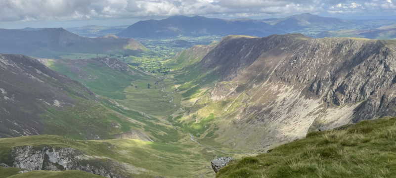
It was then upwards until we met the start of the ridge walk which would take us to the last uphill push to the summit. A quick rise to the top of Grey Height then a gradually rising ridge walk where the all-round views were improving the more height we gained, Crainlarich with its green valley and looking N you could see the recognisable shape of Beinn Dorain and to the west the summits of Bens Lui, Oss and Dubhchraig. The twin peaks of Ben More and Stobinnean were constantly in view to the E until we met the summit of the ridge walk which has Meall Dhamh to your left. We could see the summit cairn and thought ‘eh ? have we got to go there? we had to.

The summit from the top of the ridge walk

The summit from the top of the ridge walk

It was now descent time into the bealach 150 ft below then it was a quick up and over another lump of rock until it was time to strike up the last steep section, this was proving a bit of a hill too far for myself. Just as we struck out for the top, we worked Robin PKT who was on Gaor Bheinn (Gulvain) then relentlessly we drove on and the summit was slowly getting nearer but every time I checked the gps phone app, I swear the summit was moving further east or I was going in reverse. Roddy then pressed on but just at the point I was cussing under my breath at my stupidity, I met the path between summits and off I headed (slowly) to the left and after another up and over, the summit was metres away.

I first, headed to the summit cairn and touched it. Sadly there was no trig point (white or otherwise). Roddy by this time had ‘activated’ the hill. I had a quick scran break and although windy I put up the 4m JPole and proceeded to call out, 15 mins later and with no contacts it was down with the 4m antenna and the 70cm JPole erected in its place, nothing again until I made contact STS (summit to summit) with both Bob AWV and Eunice UVL who were on Duncolm in the Old Kilpatrick Hills, I tried again but no takers. A bit disappointing as I had thought 4m would have been good from over 3,000ft but it was a cracking sunny day and I guess most sensible folk would be out doing more relaxing things than playing radio.

I headed back on 2m and worked Dave TAP who was in the Selkirk area then STS with Neil who was on Kirkland Hill near Kirkconnel, next STS in the log was Barry XFM who was just to the E of us on the summit of Ben Lawers. Next was by fellow blogger Graeme 2MØGIL who was on Conic Hill near Balamha. Jack COX was out hunting STS, Jack was on Dungavel Hill in Lanarkshire, next in the log was Christine YMM from Edinburgh and finally, a cracking STS to finish the day was with Colwyn CYJ who was in the Wester Ross region NW of us on Beinn Eighe – Rhuad Stac Mor near Kinlochewe approx 150 km away.

It was then time to break down the station and head back of the hill, slowly but surely the steepish section was manoeuvred and it was time to climb up the 150ft to the ridge, this was painful but soon done and it a pleasant walk back down to descend off the Grey Height and now the relentless plod down the steep grassy slope until we took a break at the ricketty bridge before the last walk down the track to the parking area on the A82. The walk was finally done ( and so was I !)

A last look at Cruach Ardrain summit then it was off back to civilisation.

Would I do it again ? No…

Would I recommend it.. Yes !

A contrast in answers but the views from the summit cairn were fantastic, too many summits to name but the twin peaks of Ben More and Stobinnean were as if you could reach out and touch them, Ben Lawers showing through their bealach, the Tarmachan ridge, Ben Nevis with its patches of snow, the trio of Lui, Oss and Dubhchraig, Ben Lomond, the Trossach hills Venue and Ledi and an old favourite far on the south horizon, the Hill of Stake.

Rather interestingly, ‘Naismith’s Rule‘ was created during a walk on Cruach Ardrain on the way to Ben More, obviously my pace wasn’t taken into consideration.

My thanks once again go to Roddy as he suffered my slow pace etc. Funnily I’ve just received a text from him about a much lighter pack will be carried next time, I must be staying at home….

I’ll explain the title of the post..

I asked Neil his views on how ‘hard’ the ascent would be and that was his reply….I fell for it again.

Information Overload…

Cruach Ardrain means ‘Stack of the high part’ or some say ‘Heap of stones’…

it is 1,046m ( 3,462 ft ) ASL

is 87 in the Munro list

Geohack info <HERE>

Round trip of over 12km.

All photos of activation <HERE>

(

(January) Radio Days

VHF….

A bit more lively on the ‘local’ front, Barrie GM0, Graham MM0 and Roddy 2M0 on occasions.

SOTA VHF activity for January

A SOTA FM Fun day had been scheduled for the 3rd of the month, unfortunately the weather conditions or more precise, the snow had proven too much of an obstacle for some.

First of all, Graeme 2M0GIL/P had let me know of his intent to activate Meikle Bin (blog link HERE ), the ‘Blowing The Cobwebs Off’ post further down this blog will explain the day in more detail. I also worked Jack, a GM4 who was on Dungavel Hill and finally Neil 2M0NCM/P who activated Beneraird in the Galloway Hills. A good effort, lads. I also spoke that day to Dennis, MM0 from Glasgow and Fred, a GM0 from Dunlop. Having a hill behind me at 659ft ASL and 15 mins away is handy.

Towards the end of the month, on the 23rd Bob, a MM1 station activated Duncolm and Ian, a MM0 station activated Broughton Heights on the 25th.

A warmer day

Duncolm from the South

On the 31st, I worked Alan, a MM0 activated East Cairn Hill in the Pentlands, this was my first 70mhz QSO !. I next worked  Robert, aGM4 on top of Tinto Hill lastly I spoke to Neil, 2M0 on Beinn a’Mhanaich.

UHF is still quiet.

HF….

I managed to suss out what my soundcard problem was and I got active again about the middle of the month, the usual Europeans and occasional DX station, the best once again a trip to Oz to Alice Springs to work a VK8 station.

If you click on the above image, you will see more detail and if you look closely you will see a faint trace below the yellow marker.  A ‘European Russia’ RX1 station replying to my CQ call.

Odds

As I noted above, hopefully that is the soundcard problem fixed. I now have Linux on my laptop, it may take me time to get to know more about this and to see how I can apply it to my radio work. I have Echolink running through the ‘Wine’ emulator, it took me sometime, another sound problem but I got there in the end.

I’m on Echolink node 493825 if anyone wants to chat.

SOTA..my ’09 participation so far

sotaimage55

Why have I participated ? If you have read earlier postings in this blog, I did portable hilltop work in the ’80 on 11 metres and the CB 27/81 band, I, although now  much older, less fit still enjoy my jaunts into the hills, SOTA activators are given points as relevant to the height of the summits, I started with a 2pt hill, Hill of Stake, the trip in to this hill (app. 6km)  took slightly under 2 hours,the walk in was a steady rising track ( just under 4km )then a slog through heather and bog….. next was Duncolm, this also took just under 2 hours although there was a track from start to finish ( app.6.5 km), easy walk but steepish in places.

A trip to Blaeloch Hill was done on the second day of International SOTA weekend ’09, this wet, wet slog (app.2.5km )took roughly an hour, Conic Hill was the next summit activated, this was a steep walk (app. 2.2 km) which took an hour but as quoted elsewhere this was the most picturesque. The first 4 point activation was Beinn Chaorach, this was the longest haul timewise so far (app. 5km ), nearly 3 hours to reach the summit via two other hills.

Almost 9 hours walking in time plus app. 22.2 kms walking to 5 hills to collect 9 activation points but I must say in my defence, I’m totally unfit, overweight and last did any serious hillwalking over 20 years, ces’t la vie but I have some summits planned to do before the end of this summer. I will, of course, be active from my local hilltops whenever possible at weekends.

Update…

I did another activation today (25/7/09), I operated from the summit of Beinn A’Mhanaich, a 4 point summit (see report above)

Portable……so far


The weather forecast for this weekend is to be windy and wet, kinda knocks any portable work on the head. I’ve some plans to do more SOTA summits in the near future but obviously the weather must be suitable.
I’ve looked back on the posts in this blog, starting from the ones where I went ‘local’ to the SOTA activations, firstly Hill Of Stake then onto Duncolm then Blaeloch Hill followed by last weekends visit to Conic Hill.
These four hills vary in different ways, for scenery, Conic Hill on the east bank of Loch Lomond wins hands down, it was a steep, rough well worn path to the top, the weather that day was sunny, we definitely chose the best weather for views. The Hill Of Stake was the highest of the four, it was a reasonable slog to get here, the old mine track for 4 km then roughly 2.5 km over rough, heathery but marshy ground with no path,the best views were to the west and south. It had a tremendous take off to the south. Duncolm, the walk in was started in misty conditions but by the time we reached the summit, the sun was shining, the views from here were good to the NW, we could see the south part of Loch Lomond. This was the easiest of all the walk ins, it started steeply then leveled out with then a steady rise to Duncolm, there was track all of the way. It really makes a difference when a path is present. Blaeloch Hill was just an uphill slog, we followed what seemed to be a track created by the ‘Cat Tracked’ survey vehicle we saw parked nearby our drop off point. The underfoot conditions were very wet practically the whole ascent, the last .5 km was a uphill trudge, the scenery was not awe inspiring then when the weather eventually cleared, views over to Arran, Mull of Kintyre, Ailsa Craig and Bute were the highlight.
A total of four summits for 5 SOTA Activator points, not much but a start, hopefully more activations to follow.
Over the four activations, two contacts were made into to NI plus one into G land and numerous around GM land, as NE as Muirhead nr. Dundee , E to Fife, SW to Girvan as well as many more plus all the contacts made N to Robin, a GM7/P SOTA regular,furthest being one to the NE of Fort William ( an ‘STS‘ (Summit to Summit))
The local hills, Corlic, Dunrod and Auchinleck have all proved fun to work from, only Creuch left to visit, 1447 ft asl but unqualified for SOTA, the take off N,W and E is excellent, be interesting to see the results from a session on there. Here’s hoping the weather improves soon.

Photo:

Me !! at the top of the Hill of Stake